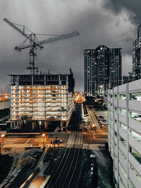
by Skyhawk | Jul 13, 2025
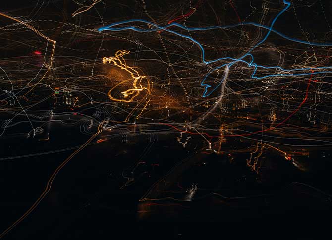
Aerial Security Mapping Overlays
At SkyHawk Survey Solutions, we provide advanced aerial security mapping overlay services in Virginia, empowering clients with real-time geospatial security risk assessments, vulnerability analysis, and asset coverage.
Our aerial overlays use GIS data, thermal imaging, and perimeter security lines to visualize threats, mitigate risks, and ensure strategic security planning for sensitive facilities, high-value sites, and critical infrastructure.
Integrated Risk & Response Planning
SkyHawk’s security overlays are not just maps—they are dynamic risk management tools. We align each overlay with a tailored threat vulnerability assessment (TVA) that includes:
- Risk grading by sector and asset value
- Adversary approach path analysis
- Security technology placement optimization
- Response force staging and timing models
- Protective intelligence heat maps
Our approach is rooted in Department of Defense and federal security protocols, led by our founder’s decades of experience in program protection, physical security, and risk mitigation for government and private-sector operations.
What Are Security Mapping Overlays?
Security Mapping Overlays are custom aerial security maps enhanced with layered security data—such as:
- Perimeter security lines (fences, barriers, gates)
- Camera fields of view (FOV) and blind spot identification
- Access control points and chokepoints
- Lighting coverage zones (day/night)
- Patrol routes and response timelines
- Intrusion detection sensor zones
- Entry/exit risk matrix overlays
- Thermal imaging overlays for nighttime and obscured area monitoring
These overlays integrate seamlessly with aerial photogrammetry and orthomosaic data to provide a high-resolution, 3D view of your facility—allowing clients to identify coverage gaps, surveillance deficiencies, and potential access vulnerabilities before a threat becomes a breach.
Key Benefits of Security Mapping Overlays
- Geospatial risk data for asset protection
- Intrusion detection zones for real-time monitoring
- Thermal imagery overlays for nighttime surveillance
- Camera field of view (FOV) and blind spot analysis
- Quick deployment of real-time security maps
Ready to enhance your facility’s security? Contact SkyHawk Survey Solutions today for a comprehensive security mapping assessment and discover how our aerial overlays can identify vulnerabilities before they become threats
What are security mapping overlays used for?
Security mapping overlays are used to visualize and assess security risks across sensitive facilities and critical infrastructure. They combine aerial imagery, GIS data, and security features such as perimeter lines, camera coverage, and intrusion detection zones to identify vulnerabilities, optimize security placement, and improve situational awareness.
How does aerial security mapping improve threat detection?
Aerial security mapping enhances threat detection by providing high-resolution, real-time imagery that highlights potential vulnerabilities, blind spots, and risks. The integration of thermal imaging overlays, camera FOV, and intrusion detection zones allows security teams to detect threats before they escalate, ensuring proactive threat mitigation and faster response times.
What industries use security overlays for risk assessment?
Security overlays are used across various industries, including government facilities, real estate, construction, critical infrastructure, energy, manufacturing, and transportation. These industries rely on aerial security mapping overlays for vulnerability assessments, risk management, and security optimization to protect assets and ensure safety.
What types of data are included in security mapping overlays?
Security mapping overlays include perimeter security lines, camera fields of view (FOV), intrusion detection zones, thermal imaging, and access control points, offering a comprehensive risk assessment.
How are security overlays integrated with existing security systems?
Our security overlays integrate seamlessly with your existing surveillance systems, GIS data, and physical security infrastructure to enhance real-time monitoring and threat response.
by Skyhawk | Jul 13, 2025
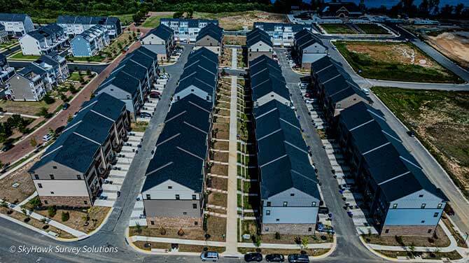
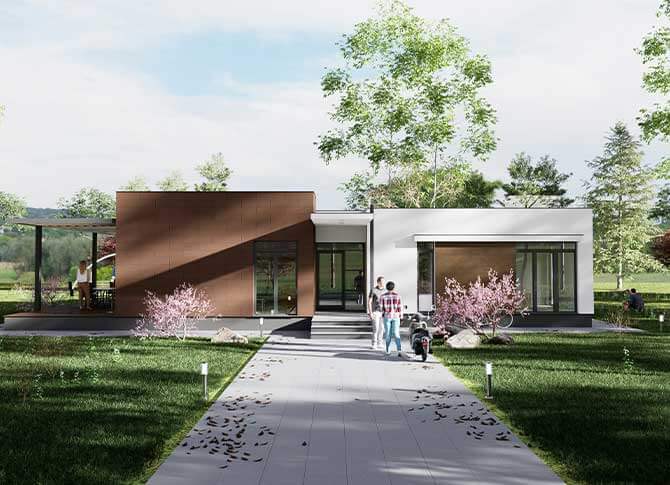
At SkyHawk Survey Solutions, we offer cutting-edge 3D renderings and aerial modeling services that transform drone-captured data into visually compelling, highly accurate, and interactive three-dimensional models.
These models provide true-to-scale visualizations of land, structures, and infrastructure—supporting decision-making across industries like construction, real estate, energy, security, and emergency response.
What Are 3D Renderings in Virginia?
3D renderings are digital, photorealistic models created from overlapping aerial images captured by our drones. Using advanced photogrammetry software and LiDAR-compatible workflows (when applicable), we stitch together hundreds or thousands of high-resolution images to form:
- Detailed 3D mesh models of buildings, terrain, and infrastructure
- Topographic surface models and point clouds
- Textured 3D maps with real-world accuracy and geolocation
- Interactive fly-through simulations for site walkthroughs and planning
Key Features of Virginia 3D Drone Renderings
- Centimeter-level accuracy (depending on ground control setup and environment)
- Integration with AutoCAD, GIS, Revit, and BIM platforms
- Annotated models for inspection, asset tracking, or documentation
- Volumetric measurement (e.g., stockpiles, excavation zones)
- Time-lapse 3D modeling for construction progress tracking
Use Cases and Industry Applications
Our 3D rendering service is customized to meet the needs of commercial, industrial, and public-sector clients:
Construction & Engineering
- Pre-construction planning and bid support
- Earthworks and volumetric tracking
- Site logistics and design validation
- As-built documentation and change detection
Real Estate Development
- 3D models for marketing, investor presentations, and site tours
- Accurate visualization of elevation, layout, and neighborhood context
Municipal & Emergency Response
- 3D mapping of disaster zones, fire paths, and structural collapses
- Real-time visualization for urban planning, emergency logistics, or incident command
Energy & Utilities
- Digital twin creation for towers, substations, and solar farms
- Inspection of hard-to-access infrastructure with full spatial context
Security and Site Analysis
- Perimeter security modeling and line-of-sight (LOS) analysis
- Visual overlays for camera coverage, access points, and blind spots
Why SkyHawk?
- Veteran-owned, FAA Part 107 certified, and experienced in secure site operations
- Trained in physical security, risk management, and mission-critical support
- Equipped with high-performance drones and photogrammetry tools
- Deliverables tailored to engineering, compliance, and operations teams
We provide clients with final 3D renderings in multiple formats:
- .OBJ, .FBX, .LAS, or .PLY for modeling platforms
- Online, shareable 3D viewers
- Secure client portals for download and collaboration
Let Us Elevate Your Perspective About 3d Aerial Rendering
SkyHawk’s 3D rendering capabilities enable our clients to see, measure, plan, and respond like never before. Whether you’re managing a complex infrastructure project, conducting a site assessment, or planning a high-security facility—our aerial models deliver the clarity and context you need to make smarter decisions from every angle.
What are 3D renderings?
3D renderings are digital models created from aerial images, providing accurate, interactive visualizations for planning and decision-making.
How accurate are SkyHawk’s 3D renderings?
Our 3D renderings offer centimeter-level accuracy, depending on ground control setup and environment, ensuring precise models.
What industries use 3D renderings?
3D renderings are used in construction, real estate, energy, security, and emergency response for visualization, planning, and documentation.
What is the benefit of using 3D renderings in construction?
3D renderings help with pre-construction planning, bid support, site logistics, and as-built documentation, improving project accuracy and efficiency.
How can 3D renderings assist in real estate development?
3D renderings offer accurate visualizations for marketing, site tours, and investor presentations, improving project decision-making.
by Skyhawk | Jul 13, 2025
At SkyHawk Survey Solutions, we provide high-resolution drone-based roofing inspections that are faster, safer, and more cost-effective than traditional manual methods. Whether you’re a property owner, insurance adjuster, contractor, or facilities manager, our aerial inspection services deliver precise visual data without the need for ladders, scaffolding, or rooftop access.
Our FAA Part 107 certified pilots use cutting-edge drone technology equipped with zoom cameras and thermal imaging sensors to detect and document roofing issues quickly and accurately—minimizing downtime and reducing liability for our clients.
Get A Clear View From Above
Whether you’re filing a storm damage claim, validating contractor work, or planning preventative maintenance—SkyHawk delivers clear, reliable, and actionable aerial roofing data that helps you make informed decisions and avoid costly surprises.
What We Deliver
SkyHawk’s roofing inspections are tailored to meet residential, commercial, and industrial needs. Our drone inspections provide:
- High-resolution imagery of all roof slopes, edges, and structural features
- Close-up imaging of specific areas of concern (cracking, blistering, punctures, ponding, etc.)
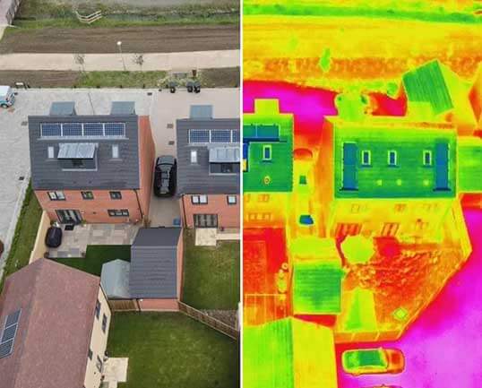
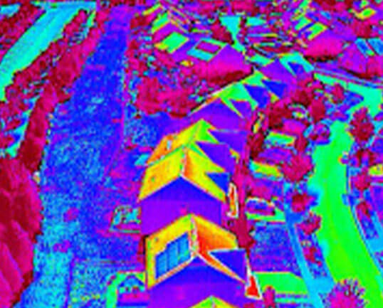
- Thermal imaging overlays to detect hidden moisture intrusion, insulation gaps, or potential leaks
- 3D roof modeling for measurement and planning
- Annotated inspection reports with time-stamped photos and geolocation data
Ideal for:
- Property managers evaluating routine wear and tear
- Roofing contractors needing pre-bid and post-installation documentation
- Insurance professionals requiring loss assessments or hail/storm damage validation
- HOAs and building owners performing preventative maintenance
- Solar contractors conducting structural checks before panel installation
Key Benefits
- No roof access required – keeps your team off ladders and reduces fall risk
- Faster turnaround – inspections completed in a fraction of the time
- Safe for steep, brittle, or fragile roofs (metal, tile, membrane, etc.)
- Thermal analysis uncovers hidden issues invisible to the eye
- Digital deliverables ready for insurance claims, estimates, or engineering reviews
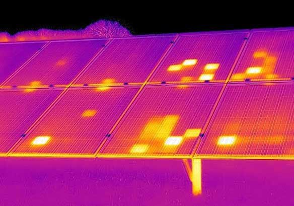
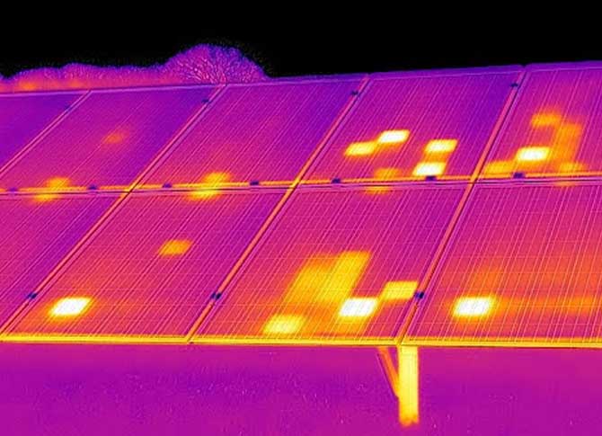
Thermal Roofing Inspections
With FLIR-equipped drones, SkyHawk can detect heat anomalies that indicate:
- Moisture under flat or membrane roofs
- Heat loss from damaged insulation
- Active leak paths after recent storms
- Areas requiring further invasive testing or patching
Our thermal imaging is ideal for commercial aerial roof inspection in Virginia, especially for flat roofs, warehouses, schools, and large complexes. It provides fast and actionable insight without damaging the roofing system. Our thermal imaging is ideal for commercial flat roofs, warehouses, schools, and large complexes, providing fast and actionable insight without damaging the roofing system.
Ready to get a comprehensive view of your roof’s condition? Contact SkyHawk Survey Solutions today to schedule your drone roof inspection.
What is drone roof inspection?
Drone roof inspection is a modern method that uses advanced drone technology to conduct thorough visual assessments of roofing systems without the need for ladders or physical roof access.
How does thermal imaging benefit roofing inspections?
Thermal imaging detects hidden issues like moisture and leaks, helping identify damage invisible to the naked eye.
What are the benefits of using drones for roof inspections?
Drones offer safer, quicker, and cost-effective roof inspections, providing detailed, high-resolution images without physical access.
Is drone roof inspection safe for all roof types?
Yes, drones are safe for all roof types, including steep, fragile, and damaged roofs, reducing fall risks and ensuring efficiency.
How quickly can I get the results of a roof inspection?
SkyHawk provides fast turnaround times for roof inspections, delivering actionable data and reports in a fraction of the time compared to manual methods.
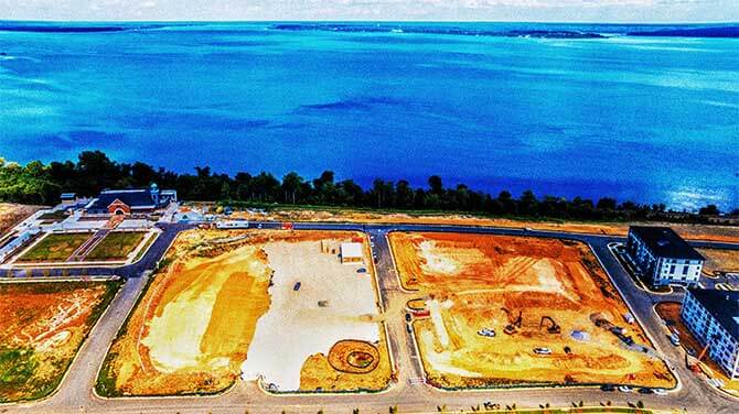
by Skyhawk | Jul 13, 2025
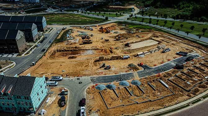
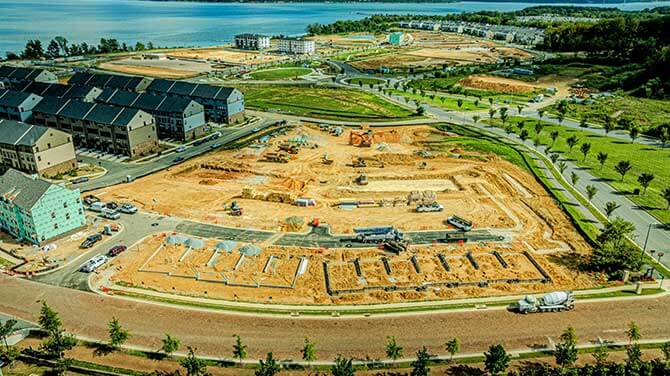
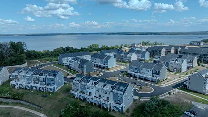
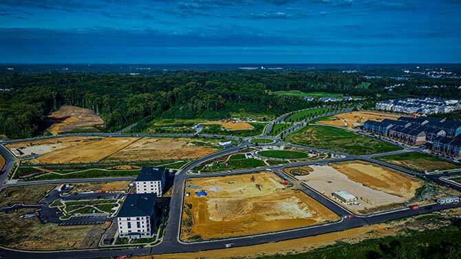
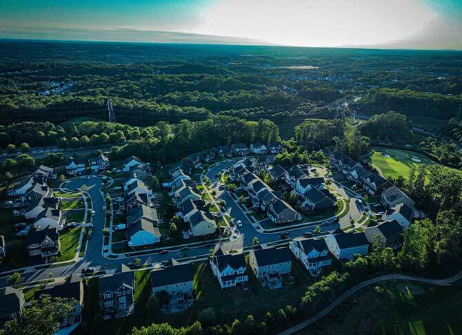
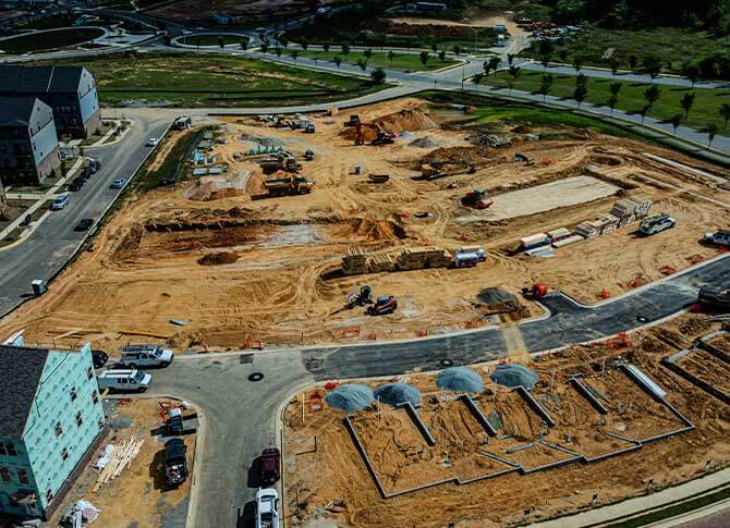
Construction Progress Timelapses
At SkyHawk Survey Solutions, we provide aerial construction progress timelapse services that give stakeholders a powerful visual narrative of your project’s evolution—from groundbreaking to ribbon-cutting. Our drone technology captures consistent, high-resolution images at scheduled intervals, allowing us to create professional-grade timelapse videos and interactive visuals that document every phase of your build.
Whether you’re managing a commercial development, public infrastructure project, or residential build, our aerial progress monitoring helps streamline reporting, enhance transparency, and support smarter decision-making.
Let Your Project Tell Its Story
With SkyHawk Survey Solutions, your construction project is more than just a job site—it becomes a story told through compelling aerial visuals and precise documentation. From groundbreaking to final walk-through, we help you showcase the journey, prove progress, and celebrate success—one flight at a time.
What We Provide
- Scheduled aerial flyovers weekly, biweekly, or monthly
- High-resolution stills and 4K video footage from consistent GPS-locked positions
- Dynamic timelapse videos showing progress over time
- Annotated progress snapshots for stakeholder reporting
- Visual comparisons between phases, milestones, and site evolution
- 3D mapping overlays and orthomosaics for additional spatial context
All imagery is securely delivered via client portals or direct cloud access, making it easy to download, share, or embed in internal reports and investor updates.
Use Cases & Benefits
- General Contractors & Project Managers
→ Visual proof of progress for internal coordination and subcontractor accountability
- Developers & Investors
→ Showcase build momentum to investors, lenders, and partners
- Government & Infrastructure Projects
→ Provide agencies and stakeholders with reliable construction documentation
- Marketing & Public Relations
→ Create engaging timelapse media for press releases, websites, and social platforms
Key Features
- Consistent altitude, angle, and flight path for seamless visuals
- FAA-compliant, insured aerial operations
- Fully edited timelapse videos available monthly or at project close
- Option for before-and-after flyovers and 3D render integration
- Scalable packages for multi-phase and multi-site projects
Construction Compliance & Documentation
Our timelapse deliverables also support:
- Compliance tracking
- Permit inspections and change order validation
- Safety and site condition reviews
- Claims mitigation and dispute resolution
We understand how critical accurate documentation is in the construction space—and our services are designed to provide objective, time-stamped aerial evidence that keeps your team and your project protected.
Why SkyHawk?
- Veteran-owned and trusted by commercial and government clients
- FAA Part 107 certified pilots with construction site clearance experience
- Precision flyovers powered by GPS-coordinated flight automation
- Rapid turnaround, clear deliverables, and competitive pricing
- Committed to excellence, safety, and long-term client partnerships
by Skyhawk | Jul 13, 2025
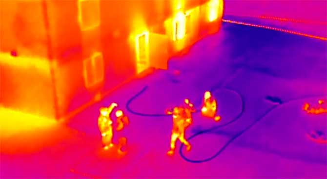
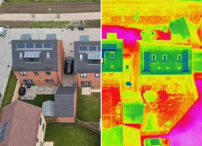
Thermal Capabilities & Inspections
Applications of Thermal Drone Inspections
- Roof Inspections: Detect leaks, insulation gaps, and structural weaknesses.
- Solar Panel Analysis: Identify faulty or underperforming cells to improve efficiency.
- Electrical Systems: Locate overheating connections, transformers, or power lines.
- Mechanical & Industrial Equipment: Spot overheating motors, bearings, and machinery.
- Building Envelope Analysis: Highlight energy loss points to reduce heating/cooling costs.
- Emergency Response: Assist first responders in locating hotspots, missing persons, or fire risks.
Benefits of Choosing SkyHawk
- Non-invasive inspections – no scaffolding, ladders, or manual roof climbing required.
- Rapid deployment and reporting – faster turnaround compared to traditional methods.
- High-resolution thermal imaging for accurate diagnostics and documentation.
- Cost savings – early detection prevents expensive repairs and downtime.
Why Choose Us for Orthomosaic Mapping in Virginia
At SkyHawk Survey Solutions, our orthomosaic mapping services give you a clear, accurate, and actionable view of the terrain—empowering you to build smarter, respond faster, and plan with confidence. Whether you’re managing infrastructure, assessing damage, or developing land, we deliver precision aerial data you can rely on.
What We Deliver
Our orthomosaic maps are processed using advanced photogrammetry software to generate:
- 2D high-resolution orthoimagery with centimeter-level detail
- Georeferenced TIFF and JPG files for integration with CAD, GIS, and mapping software
- Map overlays with property boundaries, elevation lines, or infrastructure layouts
- Digital surface models (DSMs) and contour line exports for topographic analysis
- Color-corrected, high-fidelity maps suitable for inspections, site plans, and visual reports
We provide clients with access to maps via downloadable links, interactive portals, or direct file transfers in the formats you need.
Key Benefits of Orthomosaic Maps
- Accurate to scale – supports distance, area, and volume measurements
- Updated visual data – capture changes across time and site conditions
- Fast delivery – maps processed within 24–72 hours, depending on size and complexity
- Non-invasive – no ground disturbance or boots on the ground
- Cost-effective – more affordable and safer than traditional survey methods for large sites
Applications Across Industries
Our orthomosaic maps serve clients in both public and private sectors, including:
Construction & Site Development
- Pre-construction site planning and earthwork analysis
- As-built documentation and progress tracking
- Quantity takeoffs and stockpile volume calculations
Land & Asset Management
- Boundary identification and encroachment verification
- Infrastructure and utility network overlays
- Vegetation indexing and erosion monitoring
Agriculture & Environmental Monitoring
- Crop health analysis (when paired with NDVI sensors)
- Watershed and drainage analysis
- Reclamation, restoration, and environmental compliance
Emergency Management & Disaster Response
- Rapid post-disaster mapping
- Flood modeling and debris assessment
- Real-time situational awareness for response planning
Contact us today to schedule your orthomosaic drone mapping consultation and receive high-resolution, georeferenced aerial maps for your project.
What is an orthomosaic map?
An orthomosaic map is a high-resolution, georeferenced aerial map created by stitching drone images together, offering true-to-scale, top-down views for precise measurements and spatial analysis.
What are the benefits of using orthomosaic maps?
Orthomosaic maps provide accurate, georeferenced data that supports distance, area, and volume measurements. They are non-invasive, cost-effective, and can be updated frequently, making them ideal for construction, land management, and environmental monitoring.
How accurate are orthomosaic maps?
Our orthomosaic maps are accurate to the centimeter level. With advanced photogrammetry, we ensure precise spatial data that can be used for detailed planning, topographic analysis, and decision-making.
Can orthomosaic maps be used for environmental monitoring?
Yes, orthomosaic maps are ideal for environmental monitoring, including vegetation analysis, watershed and drainage studies, and erosion monitoring. They provide clear, accurate visual data for assessing land conditions and changes over time.
What industries benefit from orthomosaic maps?
Orthomosaic maps are valuable for industries like construction, real estate, agriculture, environmental monitoring, emergency response, and land management. They provide precise, actionable insights for project planning, asset tracking, and real-time analysis.